Historical National Park in Haiti: A Landscape and Cultural Treasure
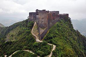
The Historical National Park of Haiti, located in the northern part of the country, stretches through the heart of the Northern Massif and extends into the Dominican Republic. Its morphological structure is complex, featuring a limestone massif with steep slopes to the west (Bonnet-à-l’Evêque, site of the Citadel) and the south (Kamadi), shaped by runoff waters that give it a rugged appearance. The park also comprises volcanic massifs (Jérôme, Ginette, etc.) cut by numerous ravines, descending north to Milot and south into the Brostage Valley. It is situated at the junction of the “coastal plain” and the “interior mountain” regions.
The strategic choice to construct the famous Citadel on these summits deviated from the coastal defense strategy inherited from the French settlement, thus marking the entry of the mountains into history. The grandeur of natural forms harmonizes with the architecture of these monuments, offering visitors a majestic impression and a remarkable landscape unity.
To preserve this natural gem and the accomplishments of King Christophe, the Historical National Park was established with well-defined objectives:
Cultural: Preservation and enhancement of monumental areas such as the Citadel, the Ramiers Fort, the Sans-Souci Palace, and colonial ruins.
Landscape: Protection and enhancement of the characteristic environments of the region, including volcanic hills, limestone hills, and valleys.
Human: Improvement of living conditions in the area.
To ensure effective action and avoid dispersion, the park is limited to an area of 25 square kilometers. Its boundaries extend north from the Sans-Souci site to the Brisement ravine, west along the western slope of the Bonnet-à-l’Evêque range to the Grand Gouffre, east by cutting across the Dondon Valley between the Golignant and Bellevue hills, and south by following the crests of the Corneille, Ginette, and Jérôme hills.
Since the 17th century, the area attracted buccaneers due to abundant hunting of game and wild boars (Grand Boucan). Subsequently, several settlements were established in the territory. However, the pre-Columbian remains are located outside the park’s current boundaries. Until the mid-18th century, this region played only a minor role in the rapid expansion of Saint-Domingue. The proximity to the Spanish border (Saint-Raphaël) did not encourage significant investments beyond the Cap period and the Northern Plain. The few settlements established were mainly dedicated to the cultivation of tobacco, cocoa, and indigo. However, the introduction of coffee in 1738 transformed this area into a prosperous place, with names of former coffee plantations and remains of industrial structures still present, such as a mill at Lafitte, a well at Briquis, and a dryer at Arnaud, even though most of the buildings have been razed.


